Young records that though the new Urban District Council discussed changing the name, and took the poll in 1896,
“the proposed change of name to Pinecliffe was not approved by the Hants County Council, who felt that there was not sufficient concurrence of opinion to justify the change of name, and so the matter was dropped. It is curious that the word Pokesdown should raise such dislike, so that even at the present time [1988] many would object to saying that they live in Pokesdown”.137b2
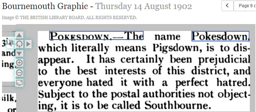
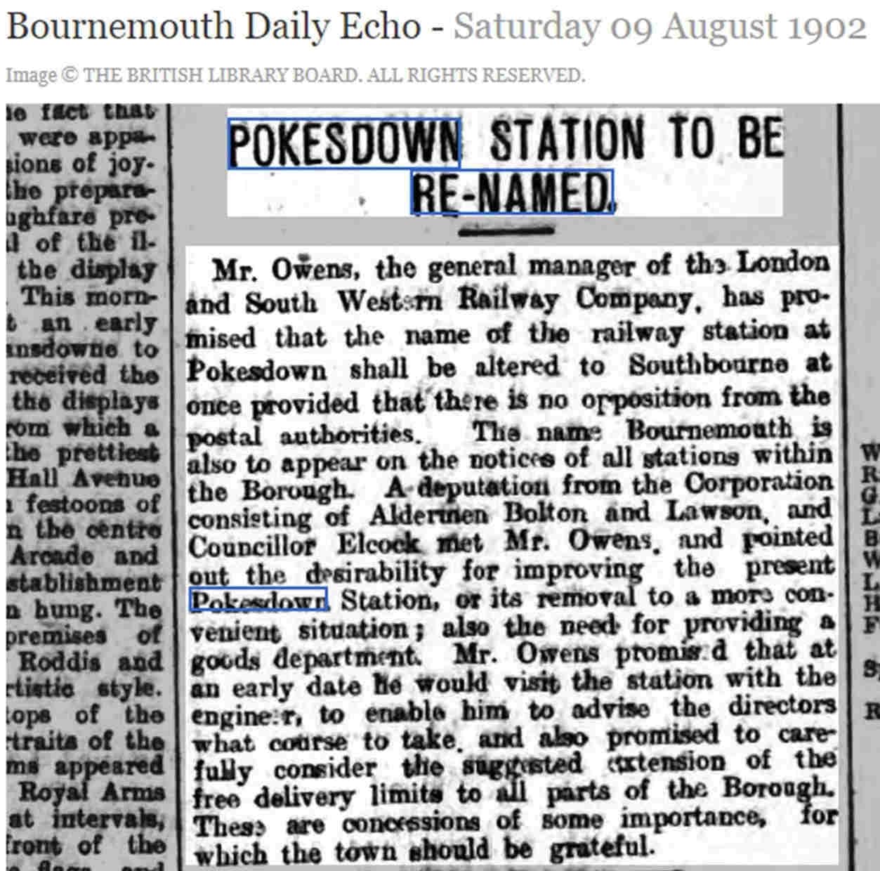
Changing the name of Pokesdown Station to Southbourne didn’t go ahead because “there were objections from a postal point of view” and a “great diversity of opinion on the matter”.137c
Bridget Baldwin’s ‘Historical Guide to St James the Greater, Pokesdown’, includes the information that in early 1931 “the Ecclesiastical Commissioners [Church of England] were asked if All Saints Church, [Oxford Avenue] Pokesdown could become All Saints Church, West Southbourne.” Baldwin describes All Saints as the “newly-built church set in an area of wealthy householders” as opposed to “the ageing Church of St James set in a poor, working-class area”. The Ecclesiastical Commissioners replied that they did not have the authority to change the name to West Southbourne.138a
Tony Crawley’s 1963 article on Pokesdown starts by saying:
“Pokesdown conjures up many pictures in people’s minds. It’s Little Pokesdown to many – unfair really, as it’s a widespread, bustling area of industry and social life. It’s the place where the trains don’t stop – to those who are glad they don’t. And, let’s be honest, to the majority, it’s the subject of ridicule in many a joke. Example: Q: Where are you spending your holiday? A: Pokesdown by the sea. And so on. It goes without saying, these ideas are wrong.”139
The copy and paste citation for this page:
The History of Rosebery Park Baptist Church and Pokesdown – Pokesdown: the name, Page 5. Author: Michelle Fogg. Date: May 2022. Url: https://roseberypark.org/history/pokesdown-the-name-5/
The History of Rosebery Park Baptist Church and Pokesdown – Pokesdown: the name, Page 4. Author: Michelle Fogg. Date: May 2022. Url: https://roseberypark.org/history/pokesdown-the-name-4/
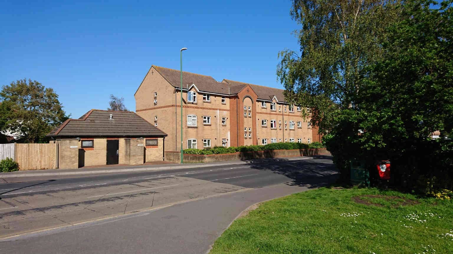
Rosebery Park Baptist Church, 812-814 Christchurch Road, between Boscombe and Pokesdown, Bournemouth, BH7 6DF
Did you know there’s a ‘Pokesdown Song’, from 1929-39, by Cumberland Clark?!
Pokesdown, on the Christchurch Road, has grown a lot of late, With the populace increasing at a very rapid rate. It’s a suburb now of Bournemouth, and a pleasant neighbourhood; It is laid out very nicely, and the architecture’s good. It once was known as “Puck’s Down,” in the happy long ago, Suggesting scenes of fairyland, where sweet romances grow; But of gorgeous wooded scenery poor Pokesdown is bereft, And I’m very much afraid there can’t be many fairies left.
Yet I call to mind the Pokesdown Wood; in memory I see its grace and charm, which some while back brought happiness to me. I have lingered in its shadows, mid a wealth of trees and flowers, And communing there with Nature, I have passed some happy hours. There were banks of moss and lichen, every kind of luscious growth; There were violets and anemones, a plenitude of both; And the sunshine glinting through the trees and brightening their green, Made a picture for the gods, a splendid transformation scene.
Where the wood was once a glory, there are houses now and streets; And there’s nothing much that’s sylvan in the scenery one meets. In my leisure moments often, since the site was built upon, I have wondered, rather sadly, where the fairies have all gone. Does it bring the fairies sorrow? Does it do them any good, When the builder’s in possession, and they’re exiled from their wood? Do they whisper farewells to us when at last they have to go? I have wondered, but I don’t suppose that I shall ever know.137
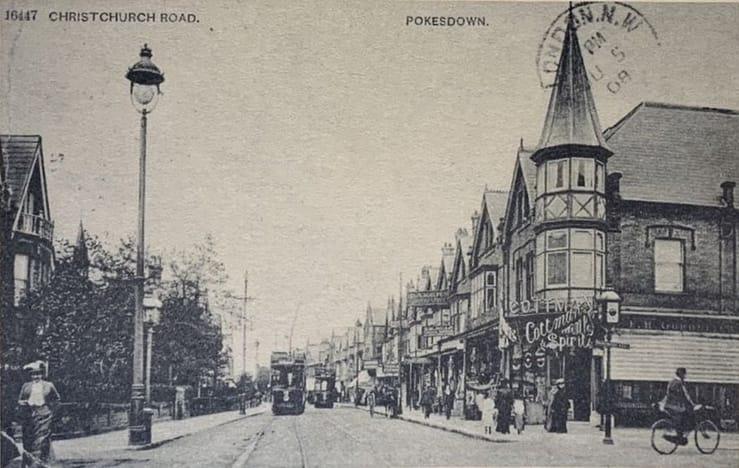
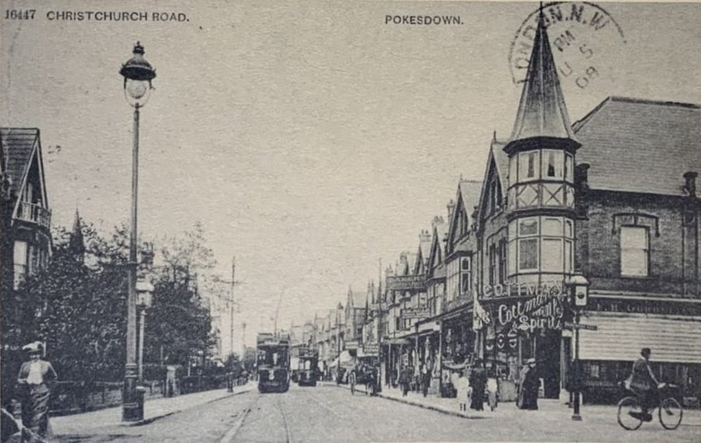
Christchurch Road, Pokesdown, looking east from Parkwood Road. The image used for the sign now on Pokesdown Green! Source: front cover of John Young’s booklet ‘A History of Pokesdown: Part 2, The Town’. Postcard is date stamped 1908.
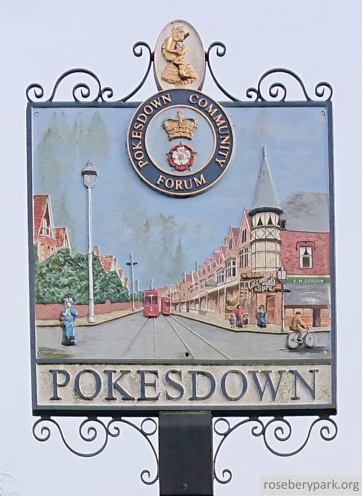
Sign on Pokesdown Green, next to the Bell Inn. Photo taken 9th March 2021 for RPBC.
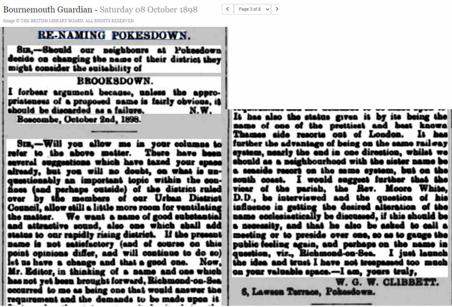
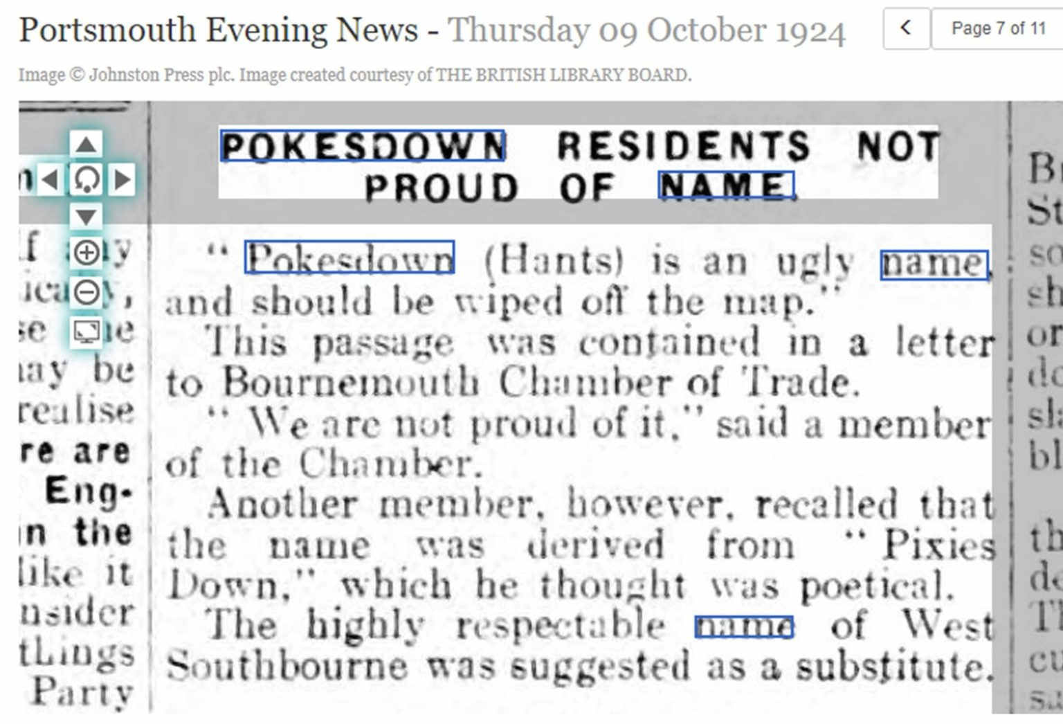
What’s wrong with the name “Pokesdown”?
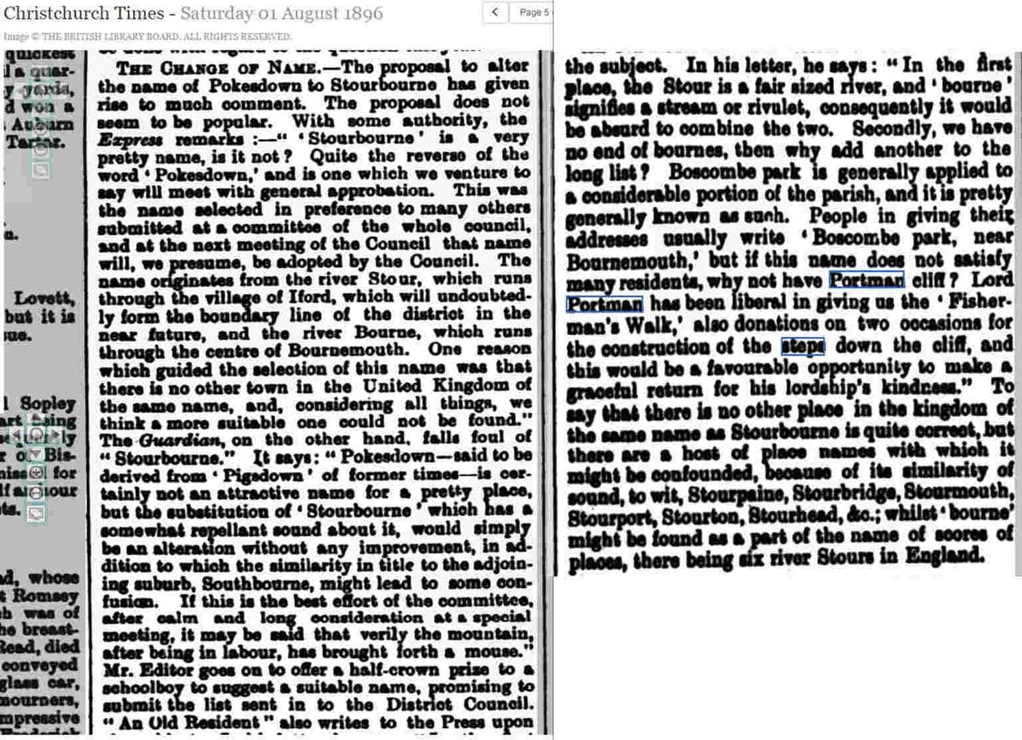
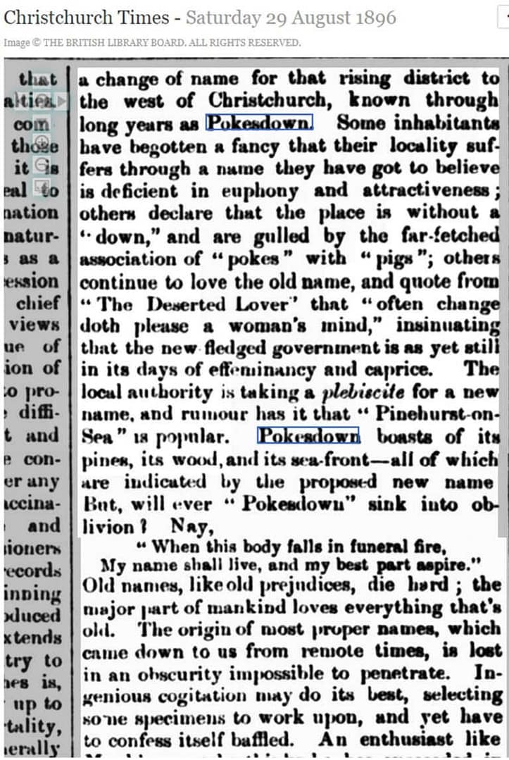
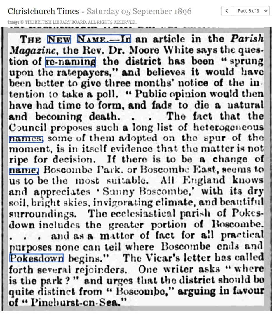
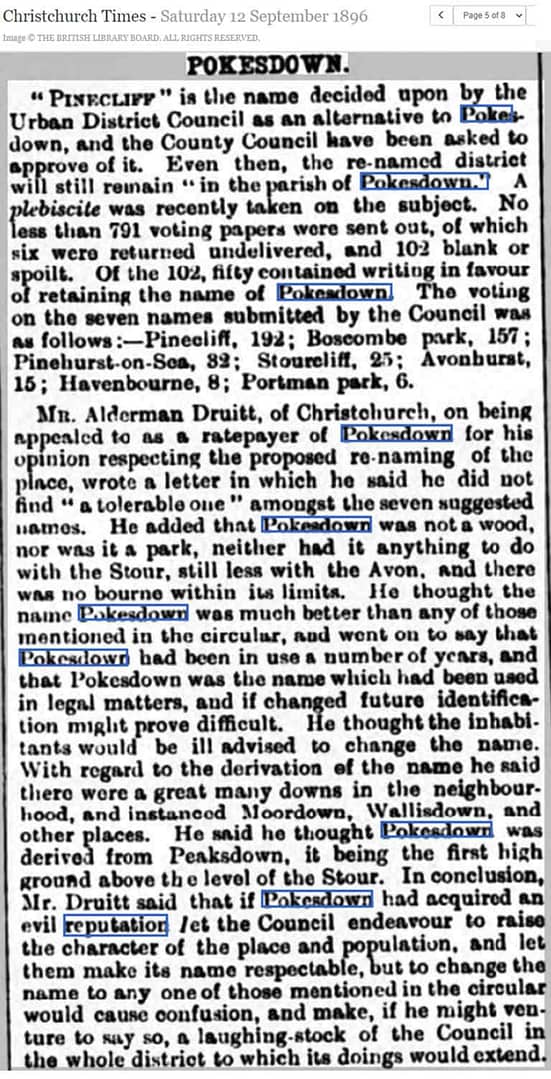
“Some inhabitants have begotten a fancy that their locality suffers through a name they have got to believe is deficient in euphony and attractiveness; others declare the place is without a ‘down’, and are gulled by the far-fetched association of ‘pokes’ with ‘pigs’; others continue to love the old name…” ~ Christchurch Times, 29 August 1896137a
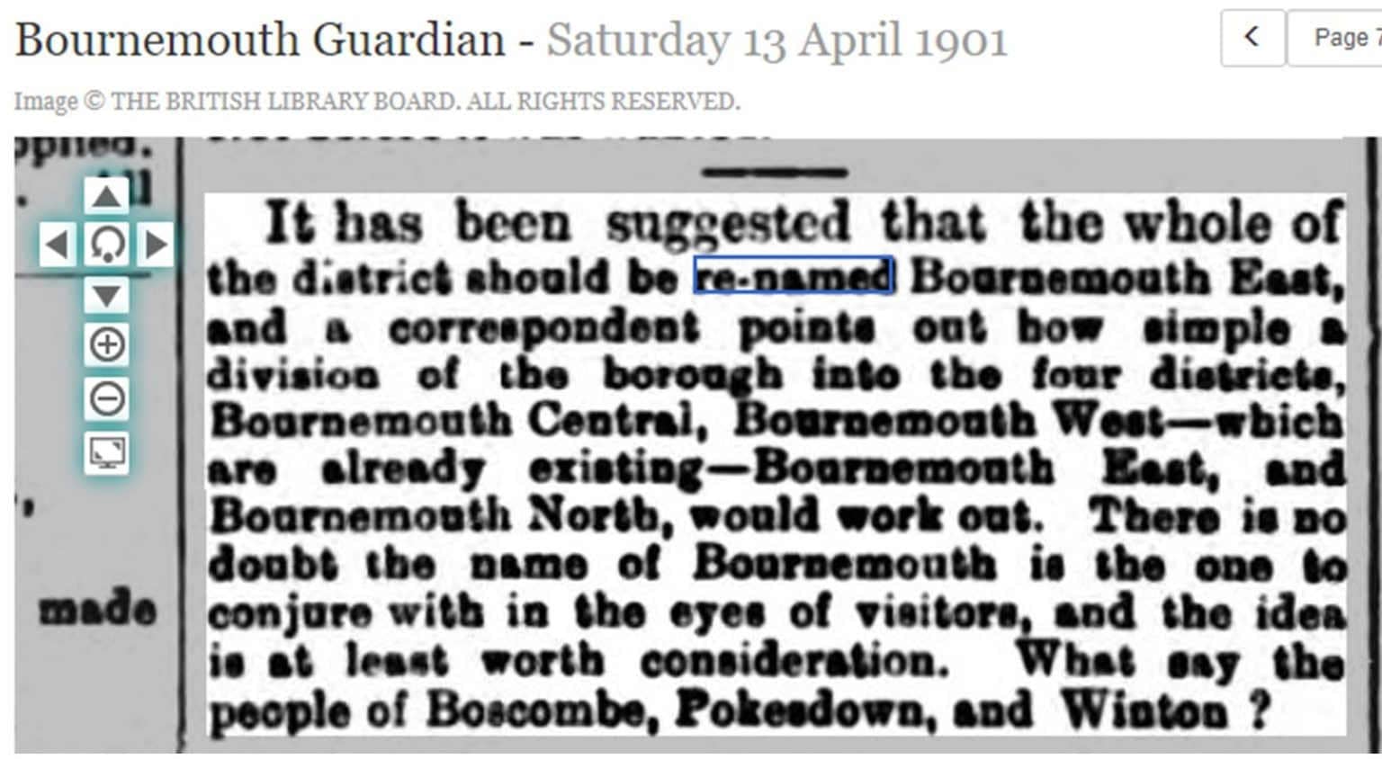
A debate about the purported lowly reputation of Pokesdown, and/or the unattractiveness of the name “Pokesdown”, has been going on for the past one hundred and thirty years! This has led some locals, businesses and estate agents to claim their properties are in Southbourne, West Southbourne, Boscombe East, or some other district name instead -because they feel that sounds better- and a repeated return to discussions about whether the name, of the area and/or the Station, should be changed altogether.
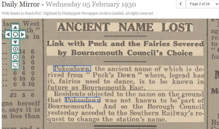
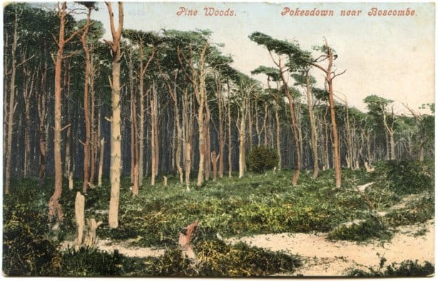
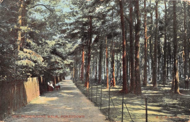
The “Pine-” based names made sense at the time because “a considerable area of Pokesdown had been planted with pine trees early in the 19th century, including much of the land along the overcliff”.137b
The History of Rosebery Park Baptist Church and Pokesdown – Pokesdown: the name, Page 3. Author: Michelle Fogg. Date: May 2022. Url: https://roseberypark.org/history/pokesdown-the-name-3/
Rosebery Park Baptist Church, 812-814 Christchurch Road, between Boscombe and Pokesdown, Bournemouth, BH7 6DF
But why would people be “seeing”, or thinking about, pixies/puck/pooka specifically in Pokesdown??!
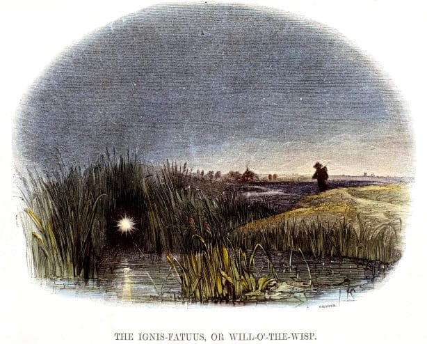
Being “pixie-led” (or “piskie-led”) refers to being mis-led, lost in familiar surroundings, losing time, never arriving at your destination. Such as what happens if you spot a light in the dark of night, somewhere there are no sources of manufactured light about, and head towards it, thinking the light is guiding you to a safe place…. But the light keeps moving, and in trying to follow it, you end up more lost than ever.134a
I feel like I’m being pixie-led, trying to back-trace the stories behind the theories of the origins of the name “Pokesdown” following paths here, there, and everywhere, and never reaching a definitive conclusion!
Those wispy lights, spotted on commons and moors at night, are thought to be the product of gases produced by organic decay, and this is not a “modern” interpretation. In 1596 Ludwig Lavater wrote a chapter called “many naturall things are taken to be ghoasts” which included reference to Willo-the-Wisps.134b “Visual and perceptual illusions of motion”134c also need to be factored in.
In Welsh folklore, this “fairy fire” is carried by a puca; in the Devon and Cornwall traditions the “pixie light” is carried by a pixie.134b The 19th century-coined serious term for this phenomena is “Ignis Fatuus” which is Latin for “Fool’s Fire”.134c
An engraving by Josiah Wood Whymper, published in 1849. Source: Science Museum Group.
Jefferey Lindell at the Indiana University Folklore Institute has compiled a list of names used to describe this same thing, and just in English there are 250 of them! They include: Will-o’-the-wisp; Kitty with the wisp; Kitty Candlestick; Jack-o’-lantern; Hob-with-a-lantern; Hob Puck; Devil’s lantern; and all of the pixie and puck variations.134c
A Pokesdown local, farmer Richard Dale, who was born in 1794, recorded his memories in the booklet Reminiscences of Stourfield – Stourfield being an early part of the development of Pokesdown. In Reminiscences he says about seeing134d
“what was commonly called Kit Candlesticks” which he had the good sense not to try and follow “as I have been told by many they had been led into difficulties and lost their way from attempting to follow, supposing that they were going in the direction of some house. Many people were kept riding about all night after them.”
I haven’t found a Bournemouth or Christchurch newspaper reference to Kit Candlesticks, but I did find an 1847 Wilts & Gloucestershire Standard article, quoting a description from 1691:134e
“Ignis fatuus, called by the vulgar Kit of the Candlestick, is not very rare on our downs about Michaelmas.”
The 1847 journalist then adds his own note to the end of this: “These ignes fatui, or Jack-o’ lanthorns, as they are popularly called, are frequently seen in low boggy grounds. In my boyish days I was often terrified by stories of their leading travellers astray, and fascinating them.- J.B.”
To know that “Ignis Fatuus” was a familiar enough sight in the Pokesdown area for it to have a name it was commonly known by – “Kit Candlesticks” – adds credence to the theory of “Pokes-“ coming from puca/pixie/puck.
The Complete Book of Devils and Demons has these notions mixed-in together in its introduction to Minor Supernatural Creatures of Britain:134f
Puck, Robin Goodfellow, Queen Mab, Tom Thumb, and many equally fanciful creatures who have not been given personal names, such as Kit with The Candlestick, Hop o’My Thumb, bugs, bogeymen, bull- beggars, fetches, sylens, firedrakes, pookas …. The pooka in Mary Chase’s play Harvey is a six-foot rabbit invisible to everyone except Elwood P. Dowel and a fine farce it makes. Some of these creatures were considered malicious, some not.
An alternative explanation for the association with fairies or pixies is, as Calkin explains, the theory that
“fairy tales are often based on ‘folk memories’ concerning some previous race which has since disappeared. It is therefore possible that the name [Pokesdown] preserves an ancient tradition about the very people whose graves have come to light during this present century” – by which he means the Bronze Age burials discovered in the Pokesdown area in the first half of the twentieth century.134g
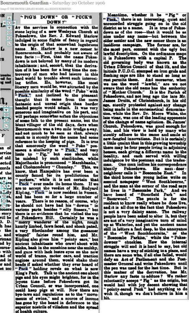
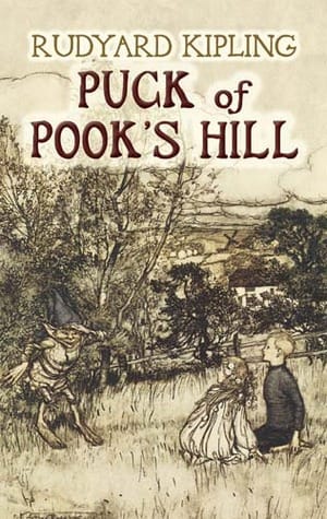
In 1906 Rudyard Kipling published a book called “Puck of Pook’s Hill”!135 I wonder if that, in part, helped cement the connection in people’s minds between “Pokesdown” and pixies/fairies?! A Bournemouth Guardian article from 1906 mentions this book, locals bumpy relationship with the name “Pokesdown”, and a theory that the name was something to do with “pigs”:
“Pokesdown” is a name of doubtful origin… Examples of earlier uses or forms of “Pokesdown” would help toward a more definite pronouncement but in the meanwhile the name should be treasured as one of the few within the borough boundary which long ante-date enclosure.136
The copy and paste citation for this page:
The History of Rosebery Park Baptist Church and Pokesdown – Pokesdown: the name, Page 2. Author: Michelle Fogg. Date: May 2022. Url: https://roseberypark.org/history/pokesdown-the-name-2/
Rosebery Park Baptist Church, 812-814 Christchurch Road, between Boscombe and Pokesdown, Bournemouth, BH7 6DF
Which parts of the area are included in Pokesdown?cont’d
A PDF of the maps is available here where they can be enlarged for easier viewing. Images can also be clicked on to open a higher resolution image in a separate tab.
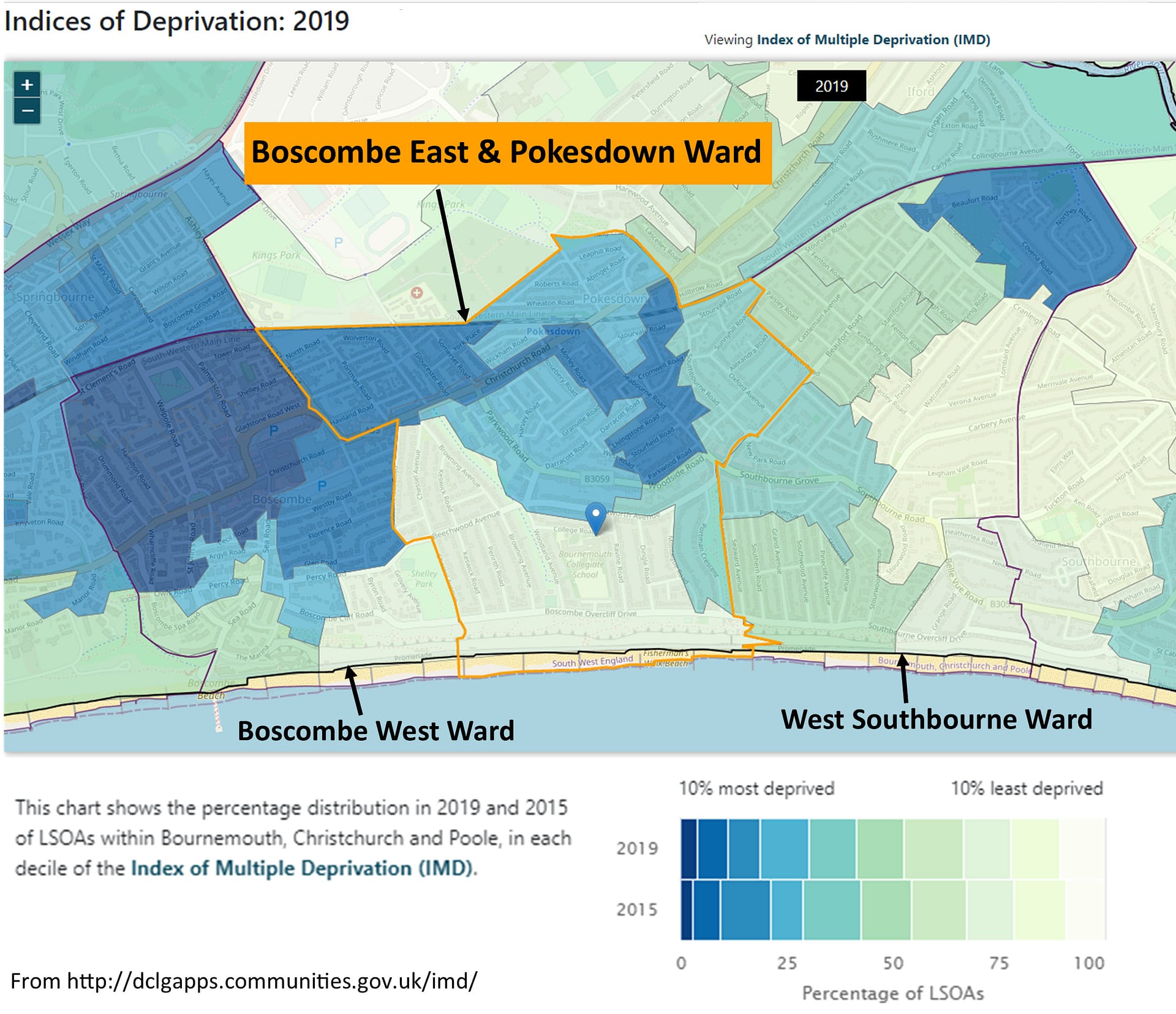
This is the modern-day political ward of “Boscombe East & Pokesdown”. It was previously called just “Boscombe East”, even though it always included Pokesdown, but the name was changed in October 2018:152
Click on image for higher resolution version.
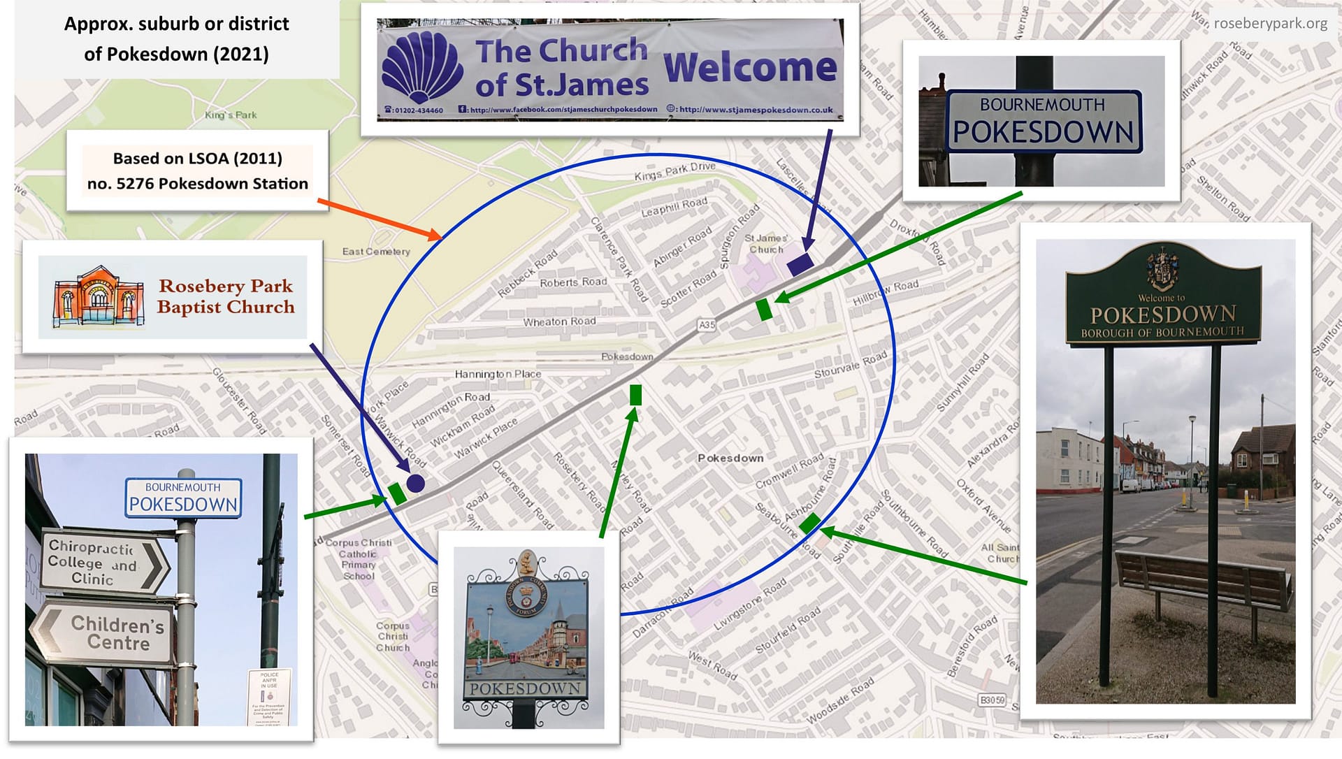
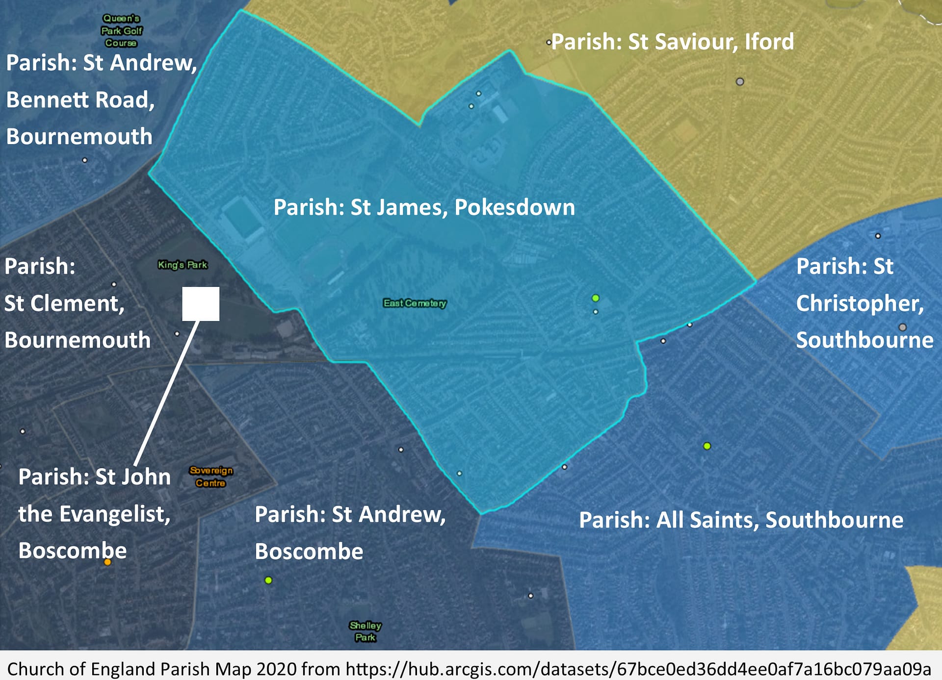
This map shows the modern-day (2021) boundary of the suburb or district of Pokesdown – a much smaller area than the other Pokesdown boundaries, but Rosebery Park Baptist Church is still in it (both current location and site of original chapel)! The original C of E parish church, St James, is still here too.
Map of suburb or district of Pokesdown today (2021), including showing original parish church of St James.153 Click on image for higher resolution version.
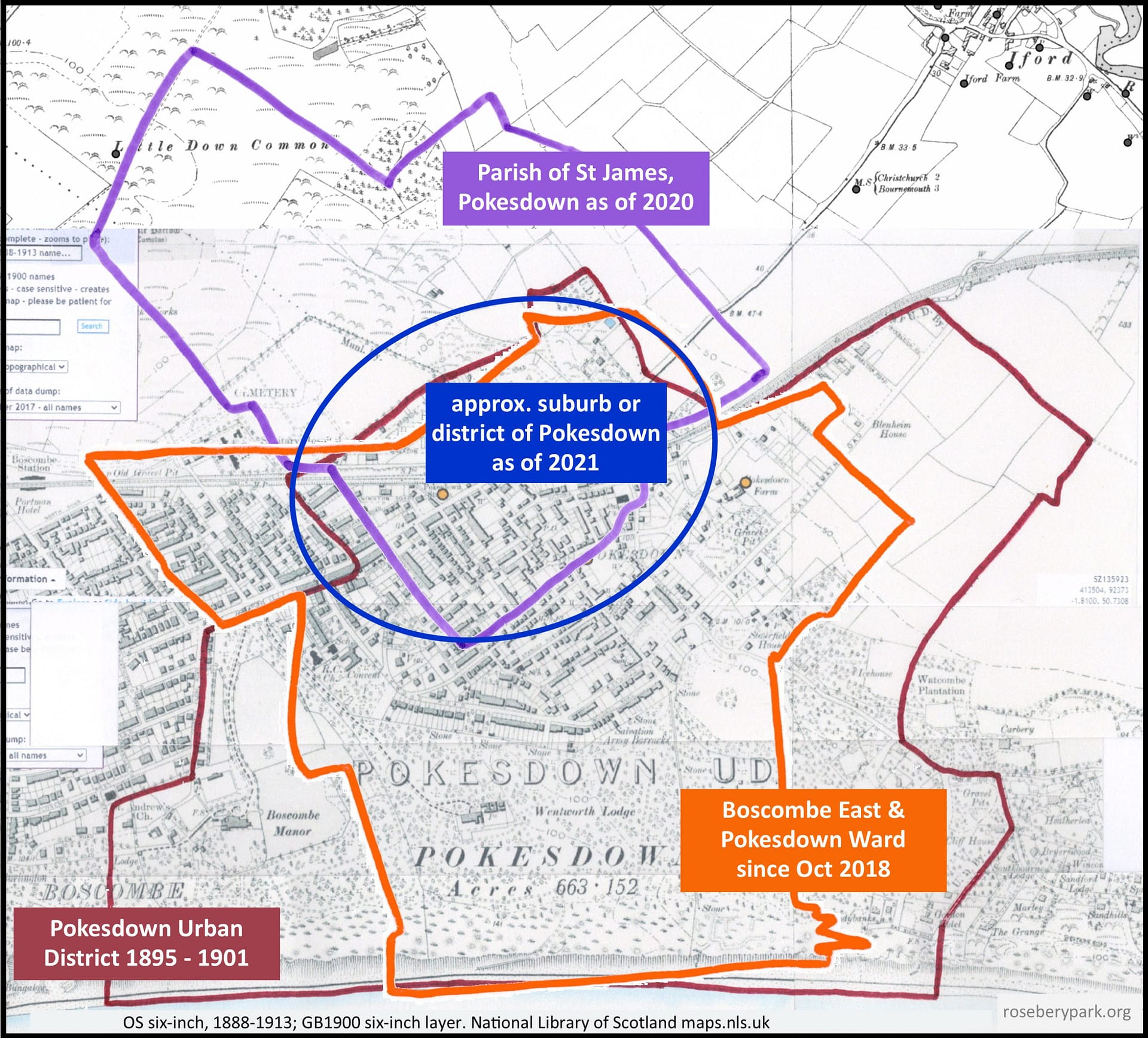
The next map shows the modern-day boundary for the Parish of St James, Pokesdown, over-laid with the boundaries for the 1895 to 1901 Pokesdown Urban District, the 2018 Boscombe East & Pokesdown Ward, and the area locals today might consider to be the suburb or district of Pokesdown. And this is why it’s difficult to say where Pokesdown begins and ends – what year and which aspect are being discussed?!154
Click on image for higher resolution version.
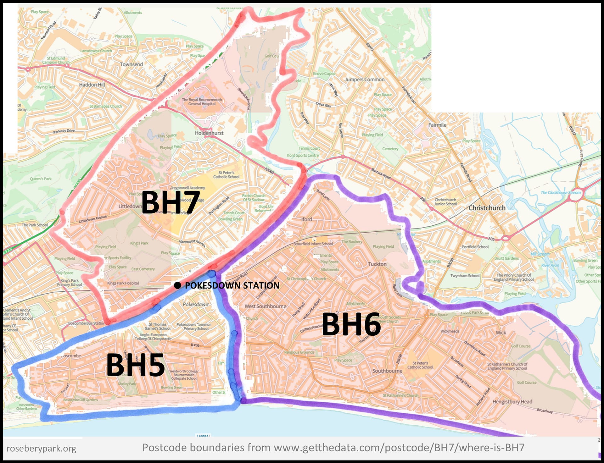
By postcode boundaries, Pokesdown is split, with the north side of Christchurch Road falling into BH7, and the south side into BH5, so postcode boundaries are not a help in defining where Pokesdown is! BH6 starts just to the east of Southbourne Road.155
Click on image for higher resolution version.
The copy and paste citation for this page: The History of Rosebery Park Baptist Church and Pokesdown – Pokesdown: its boundaries, Page 2. Author: Michelle Fogg. Date: May 2022. Url: https://roseberypark.org/history/pokesdown-boundaries-2/
Rosebery Park Baptist Church, 812-814 Christchurch Road, between Boscombe and Pokesdown, Bournemouth, BH7 6DF
Which parts of the area are included in Pokesdown?
A PDF of the maps is available here where they can be enlarged for easier viewing.Images can also be clicked on to view higher resolution image in a new tab.
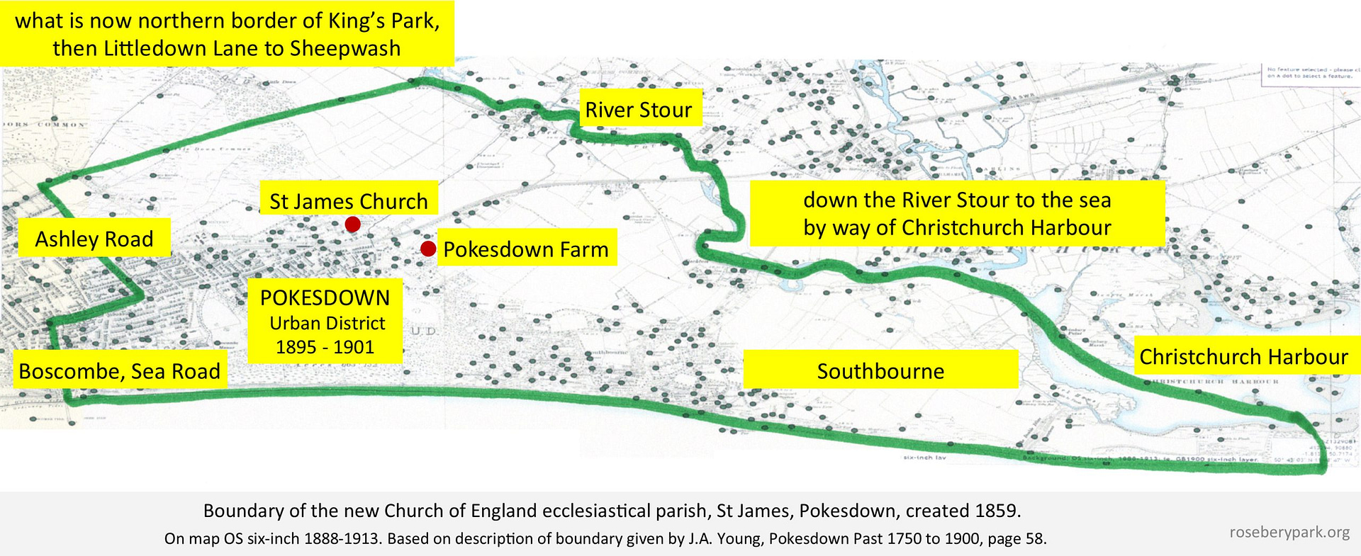
Here is a map showing the 1859 boundary of the then new Parish of St James, Pokesdown – based on the description given by J.A. Young147 – note, it covers a MUCH larger area then we are used to considering as Pokesdown!
Click on image for higher resolution version.
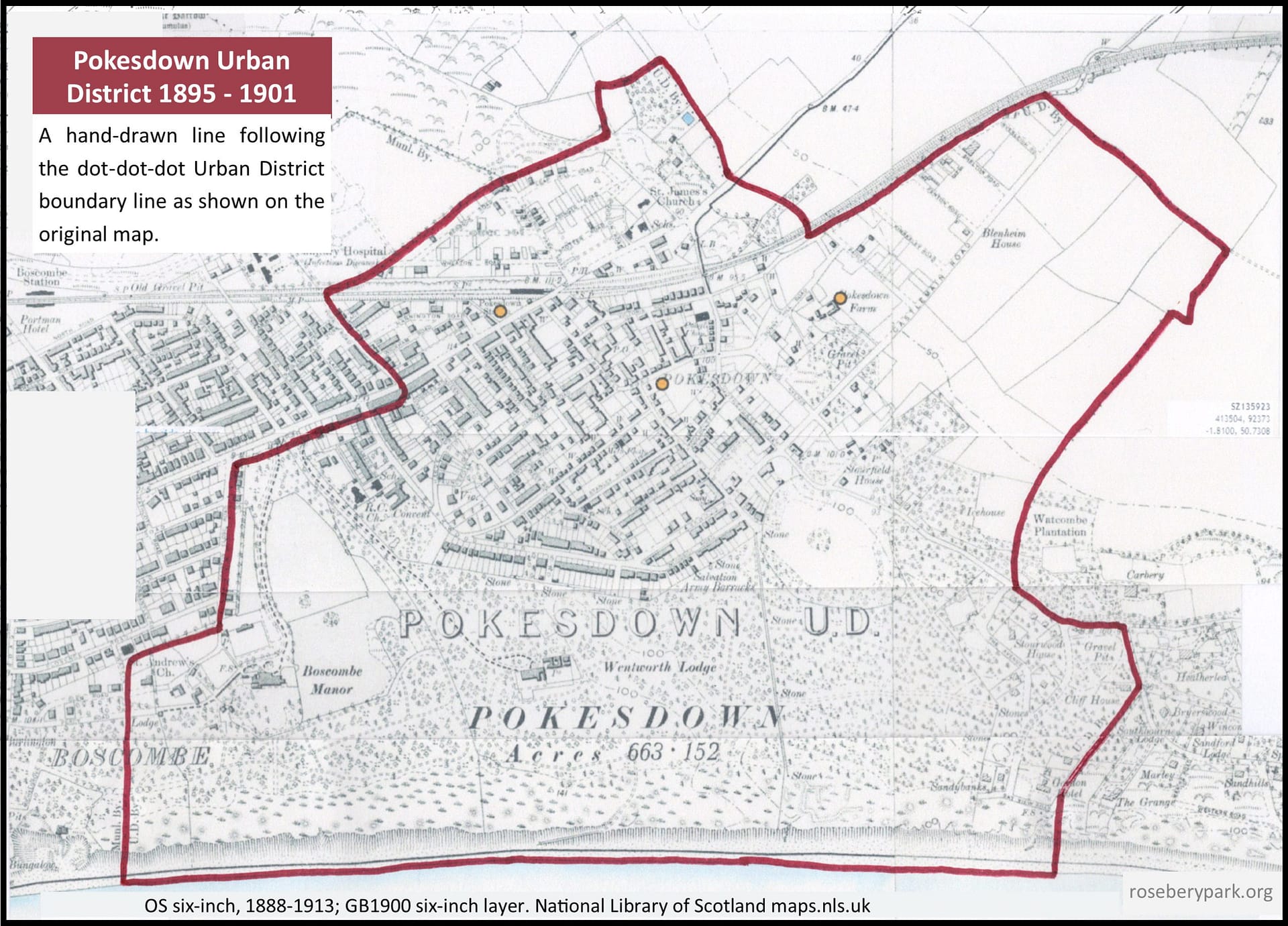
When Pokesdown became an Urban District in 1895, the boundaries were defined as running from the sea front to Wollstonecraft Road, and just east of Crabton Close Road, along south of Christchurch Road to Warwick Road, along the railway, which was crossed to take in Clarence Park, and so over part of King’s Park to beyond Harewood Avenue. It then re-crossed Christchurch Road and the railway, running alongside the line to Cranleigh Road, after which it turned towards Southbourne Road, between Irving and Watcombe Roads. It then turned into Belle Vue Road and along Clifton Road to the sea front. Thus it included the Shelley, Portman, Stourwood and Stourfield Estates.148
Click on image for higher resolution version.
The boundaries of Pokesdown seem to have always been blurry! As early as 1896, Rev. Dr. Moore White stated “for all practical purposes, none can tell where Boscombe ends and Pokesdown begins”149, and in 1916, Mrs Arthur Bell described Pokesdown as “a mere continuation of Boscombe”.150 The boundaries have also retracted, and today’s Pokesdown covers a much smaller area than it did in 1895.
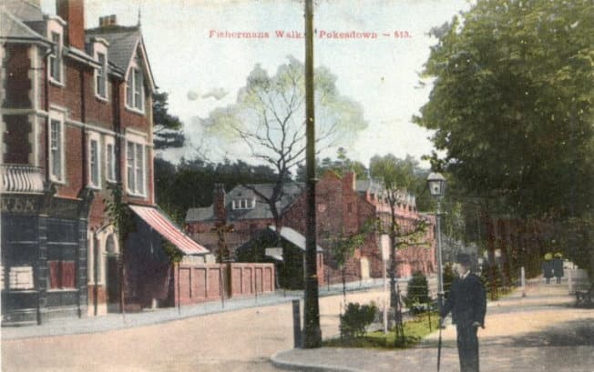
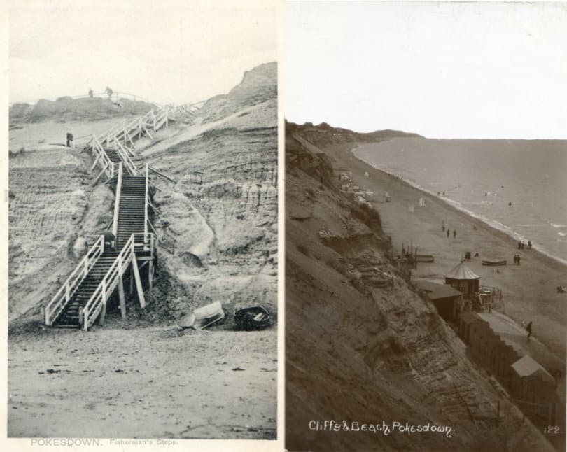
For example, Fisherman’s Walk was originally part of Pokesdown. Where we now have the Fisherman’s Walk Zig Zag to take us down to Fisherman Walk’s Beach (Southbourne), that used to be Fisherman’s Walk, Pokesdown leading to ‘Fisherman’s Steps, Pokesdown’, aka ‘Pokesdown Steps’, leading to Pokesdown Beach! The steps, first constructed in 1891, were replaced by a carefully engineered sloping path in the early months of 1906.150a We can see in the Palladium Cinema advert (on page 3 of History) that the district address of Fisherman’s Walk was given as Southbourne by 1932, which could be evidence that this change happened a long time a go… or it could be another example of someone choosing their preferred district name!
Steps Postcard by Pictorian Stationery, date: c.1905. Source: Alwyn Ladell Flickr Cliffs & Beach, date: unknown, but the refreshment kiosk (the little round hut) was new in 1907. Source: Alwyn Ladell Flickr.
This is the modern-day (2020) parish boundary of St James, Pokesdown. The 1859 parish has, over the years, been divided into multiple parishes:151
Click on image for higher resolution version.
The copy and paste citation for this page: The History of Rosebery Park Baptist Church and Pokesdown – Pokesdown: its boundaries, Page 1. Author: Michelle Fogg. Date: May 2022. Url: https://roseberypark.org/history/pokesdown-boundaries-1/
Rosebery Park Baptist Church, 812-814 Christchurch Road, between Boscombe and Pokesdown, Bournemouth, BH7 6DF
Earliest known written records with the name “Pokesdown”:
Year: c.1586. Evidence: Richard Morris of Pokesdown, Christchurch on a list of people fined for buying pirates’ goods (part of The Cecil Papers).124d
Year: 1660. Evidence: Henry Mantle of Pokesdown elected a churchwarden of Christchurch Priory.
Year: 1662-63. Evidence: churchwarden accounts record the receipt of one shilling from Henry Mantle of Pokesdown in payment “for a place for his wife where his mother did sit”.125
Year: 1734. Evidence: Christchurch Poor Rate Book, includes the line “The Lady’s Mews for Bugby’s at Pokesdown“.126
Year: 1800. Evidence: the will of Mary Eleanor Bowes, Countess of Strathmore and Kinghorne, Stourfield House – she left an annuity for the Widow Lockyer of PokesdownFarm.127
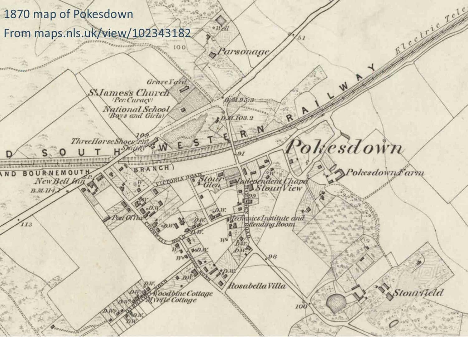
1870 map of Pokesdown showing earliest recorded settlements of Pokesdown Farm (date unknown, but pre-dates Stourfield House) and Stourfield House (est. c.1766). See Sources note 128.
There is no definitive answer about the origins of the name “Pokesdown”, but the different theories are:
It might be a corruption of ‘Peaksdown’ – ‘Peak’ – a high point in the downs (‘down’ meaning low hills covered in grass);129
It may have been a persons name associated with the down – ‘Pocs’ Down’, or the Old English surname ‘Puca’, as in ‘Puca’s Down’ has morphed into ‘Pook’ in Middle English, as in ‘Pook’s Down’;130 or if derived from the Saxon personal name “Pok” or “Pokok” then Pokesdown would mean “the hill of the Pok family”;130a
It could be from ‘Pooks Down’ where ‘pooks’ is the local dialect word for ‘haycock’ (cone shaped pile of hay). But Coates says “the 13th century with a medial ‘-s-‘ speaks against this”;131
It’s from ‘Pig’s Down’, from the days when people were allowed to keep pigs at will, before it was banned as part of the urbanisation;131a
It was an area for “poor souls stricken with the pox” = “Poxdown” (but I haven’t found any corroborating evidence);131b
The most popular (if unsubstantiated) theory is that Pook’s (or Puck’s) Down was referring to the fairies or pixies or goblins living on the downs! ‘Pook’s Down’ is Middle English for ‘Goblin’s Hill’.132
The fact that the “pig theory” is only in the newspapers and isn’t in any of the history books makes me think, either (a) it’s a theory made up by residents with local knowledge, but rejected by the academics, who are carefully analysing the etymology (the study of the origin and history of words); or (b) the academics were studying the name “Pokesdown” fifty-years-plus after the locals who could remember pig keeping at Pokesdown had passed, but years before the British Newspaper Archive was online with a searchable database of newspapers reporting on Bournemouth life, and therefore missed this titbit.
The theory about “Pox-down” comes from the Holdenhurst Village History website, which says “It is recorded that there was a Leper Hospital in Christchurch, the owners of which owned land and a cottage at Holdenhurst during the reign of Edward III [1312-1377] – it is thought that centuries ago poor souls stricken with the ‘pox’ were brought from ‘Poxdown’ (Pokesdown) for treatment at the then named ‘Hospice of St Mary Magdalen'”. But I have been unable to find the source of this theory, or any corroborating evidence, and it’s not mentioned in the history books. If you know of any information backing this theory, let us know!
Pooka, Puck and Pixies…
When it comes to the favourite theory, Your Irish Culture explains:133
The meaning of Pooka, pronounced poo-ka, is from the old Irish word ‘púca’, which means ‘goblin’. There are many variations of the spelling Pooka including Púca, Plica, Phuca, Pwwka, Puka, and Pookha all of which are totally acceptable. It is possible that the origin of the word Pooka may come from the Scandinavian word, Pook or Puke meaning ‘nature spirit’… A Pooka is a shapeshifter and can take any form it chooses. Usually, it is seen in the form of a horse, dog, rabbit, goat, goblin, or even an old man.
The Pooka has been imagined in cinema as the large rabbit-type creature, called Harvey, in the 1950 James Stewart film, and a far more disturbing rabbit-type creature in the 2001 Jake Gyllenhaal film, Donnie Darko!
But, going by the newspaper articles which discuss the name “Pokesdown”, where there are references to folklore or mythological creatures, it’s not giant, scary, malevolent rabbits (Pookas) that people are imagining, but rather, “Puck” and his fairies!
Tracing the etymology or folklore wandering path(s) that led from “pooka” to “puck”, the Encyclopedia Britannica says of “Puck”:
Puck, in medieval English folklore, a malicious fairy or demon. In Old and Middle English the word meant simply “demon.” In Elizabethan lore he was a mischievous, brownielike fairy also called Robin Goodfellow, or Hobgoblin. As one of the leading characters in William Shakespeare’s Midsummer Night’s Dream, Puck boasts of his pranks of changing shapes, misleading travelers at night, spoiling milk, frightening young girls, and tripping venerable old dames. The Irish pooka, or púca, and the Welsh pwcca are similar household spirits.134
Rudyard Kipling says Puck is living in Sussex! Published in 1906. Source: Good Reads.
“Puck” outside the Folger Shakespeare Theatre, USA. Source: David Flickr.
The copy and paste citation for this page:
The History of Rosebery Park Baptist Church and Pokesdown – Pokesdown: the name, Page 1. Author: Michelle Fogg. Date: May 2022. Url: https://roseberypark.org/history/pokesdown-the-name-1/
Rosebery Park Baptist Church, 812-814 Christchurch Road, between Boscombe and Pokesdown, Bournemouth, BH7 6DF
Rev. Dennis R. Banfield, Minister 1969 – 1980. Photo property of RPBC.
Near the start of Rev Dennis Banfield’s time as RPBC Minister, 1969/70, the alterations to the front aspect of the church were finally finished, after delays caused by reaching agreement on new fire precautions.
The new central entrance and glass divide between vestibule and sanctuary (i.e. between the entrance area and the part of church where services are held) gave the building the substantially different look it has today.99
By 1971 the evening congregation had grown, and this was attributed to the local distribution of St John’s gospels by the church. House prayer groups were set up in areas which most people could easily reach, and Rev. Banfield led a Baptist Union Training Programme.100
For the church’s 88th anniversary, an exhibition with static displays, and slides, and members to meet-and-greet, was held over four days to tell local residents about the church’s work and history of service and ministering to the community.101
Jeans writes about Rev. Banfield’s eleven-year ministry at RPBC: “Over twenty had confessed their personal commitment to Christ in baptism, the standard of worship had never been allowed to drop, spiritual life and awareness had deepened. Church and ecumenical fellowship had been strengthened and the neighbourhood made more aware of Christian faith, witness and service which were available in their locality.”102
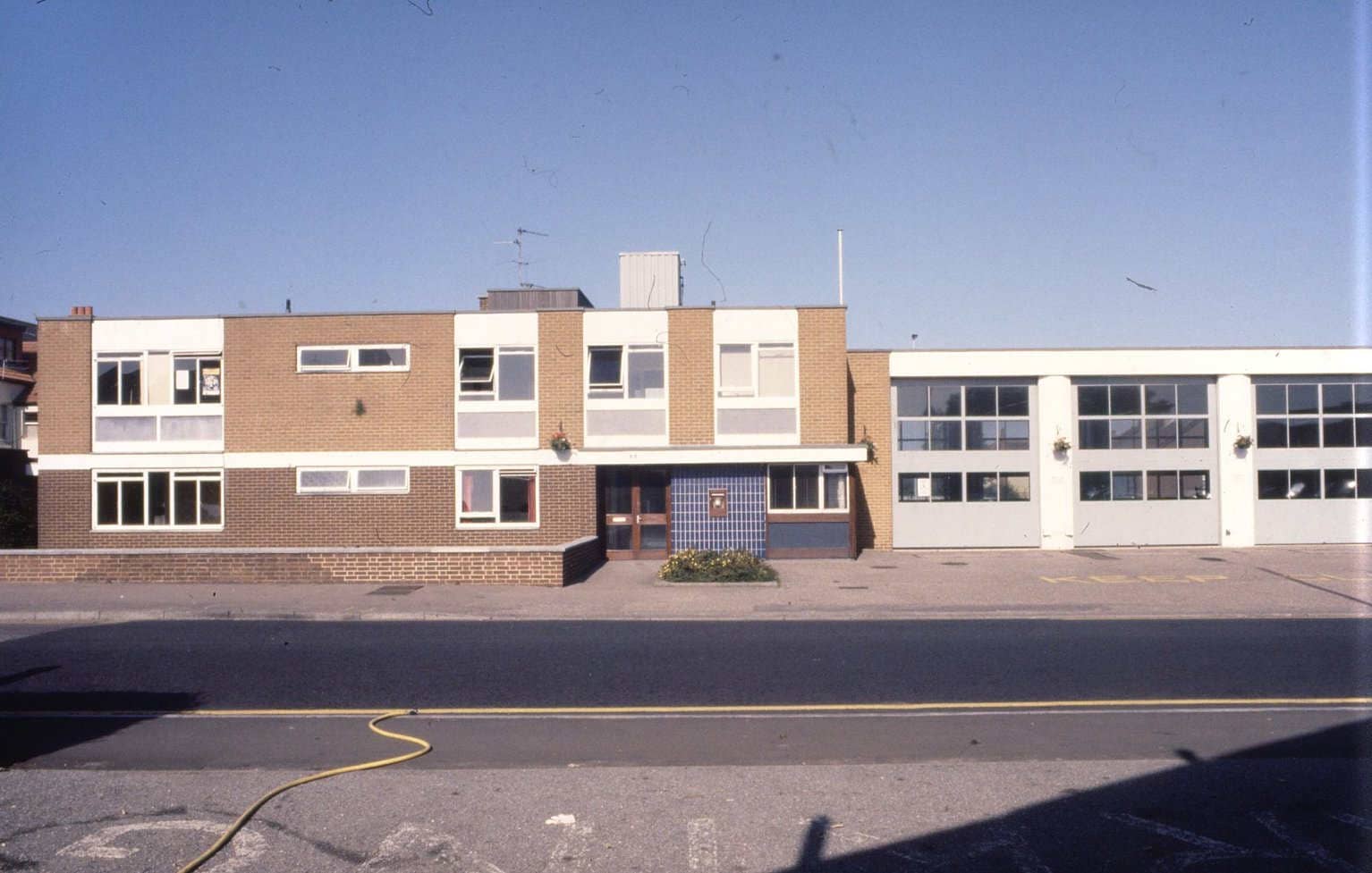
The “new” Pokesdown Fire Station, near the top of Seabourne Road, built mid 1970s, demolished about 1990. It looks very 1970s! Date of this photo: 1988. Source: Grant Flickr.
Same site today. This photo, taken for RPBC: 31 May 2021
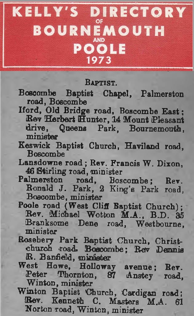
Baptist Churches listing from 1973 edition of Kelly’s Directory. Source: thegenealogystore.co.uk
Twenty-one years on from RPBC moving into its current building on Christchurch Road, and the former occupants of the building are still meeting in the venue they moved to in Haviland Road, with the name “Keswick Baptist Church” taken with them from “Keswick Hall”. While Rosebery Park Baptist Church has taken its name from the Rosebery Park Estate of yesteryear with them to what was “Keswick Hall”!! The original names, “Keswick” and “Rosebery Park”, were never inspired by any local connection – the interesting, if potentially confusing, history of church names!103
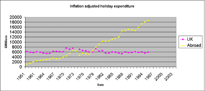
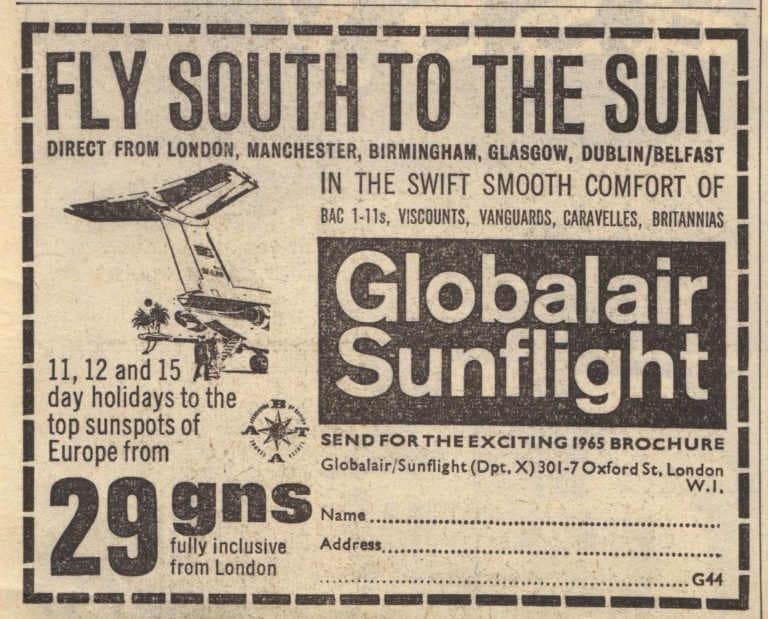
From the 1960s, holidays abroad were an option for more and more people, enabled by larger and faster aircraft (bringing economies of scale), the easing of restrictions on taking currency abroad, and rapid hotel construction in many Mediterranean countries.104 One website says: “By 1979, for the first time in history, Britons spent more on overseas holidays than on holidays at home.”105
Summaries of what was going on in the nation and locally in the late 1970s – 1980s onwards often include sobering references to “the decline of the seaside town”.
SeasideHistory.co.uk’s look at the tourist statistics suggests that rather than there being a dramatic reduction in number of visitors to seaside towns (LESS VISITORS), the problem was LESS MONEY being spent in seaside towns, as the more affluent people were now going abroad for their main holiday, with UK seaside resorts as an additional short holiday.106
The centre of Bournemouth off-set these challenges by concentrating on being home to more language schools than any other town in the UK, a growing university, and the conference trade – the Bournemouth International Centre was built in 1984 specifically to be a magnet for this.107
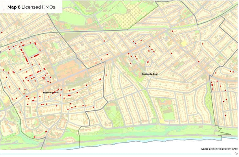
But Boscombe, along the coastline, one and half miles away, sadly does fit the “decline” picture. As the ‘Boscombe Strategic Assessment’ (published 2011) explains: “The decline of the English holiday market saw the area’s hotels and guest houses turned into Houses of Multiple Occupation (HMOs), attracting the homeless, vulnerable households and migrant workers. Demand for services is concentrated in the area – this comes from drug and alcohol users, the unemployed and benefit claimants. The problems are not unique – they are experienced by many seaside towns. Intensive efforts are needed to tackle severe social problems including high levels of population transience and the chaotic lifestyles of some residents.”108
It’s hard to tell where Pokesdown fits into this story. By the 1970s it’s been fifty years or more since Pokesdown was considered to extend as far as the beach! Checking the 1973 Kelly’s Directory by road names109 shows there were few hotels or B&Bs listed in Pokesdown itself. And if we fast-forward to 2017, the Council says there are 119 licensed ‘Houses of Multiple Occupation’ in Boscombe West, compared to only 23 in Boscombe East ward (which includes Pokesdown).110 But the Christchurch Herald article about Pokesdown in 1963 identified one of the largest local employers as the New Era Laundry, with a staff of 170 and a fleet of 15 delivery vans, “dealing with some 90,000 articles in their summer peak periods”, including 20,000 sheets.111
Maybe, like the early years of its urbanisation -when Pokesdown was where the artisans and workers lived who built and served Bournemouth- Pokesdown was still home to the workers, who were now dependent for their living on working in the supporting services needed by the tourist trade? Maybe both locals and holidaymakers were spending less money in the local shops?
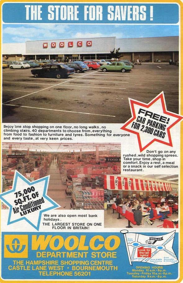
In addition to tourism related changes in the economy, local shops may also have lost trade due to the opening of an out-of-town shopping centre in 1968, The Hampshire Centre, on nearby Castle Lane West, but the impact it had is uncertain. Did the convenience of shopping there make the need to “pop” into Pokesdown redundant? Were the type of shops available at The Hampshire Centre in direct competition with Pokesdown shops? Or was it more of a threat to the centre of Bournemouth? Also, The Hampshire Centre was not necessarily a success story. By the mid 1970s a number of its units were empty.112
The History of Rosebery Park Baptist Church and Pokesdown, Page 15. Author: Michelle Fogg. Date: May 2022. Url: https://roseberypark.org/history/rosebery-park-and-pokesdown-15/
Allan Clappen, who had already financed the new organ, gave a further generous gift which enabled welcome alterations to the front of the church building. Robert J. Jeans, author of the church’s first one hundred years history, and at this time the Church Secretary, explains: “The almost blank wall facing the street (see photo top of page) did not suggest the place was a church. Alterations would provide a central entrance to a vestibule, separated by a glass screen. The public would have a line of vision from the street through to an illuminated cross over the pulpit lit from dusk until eleven o’clock each evening. The scheme included the blocking of the former entrances and cloakrooms built under the stairs to the galleries.”91
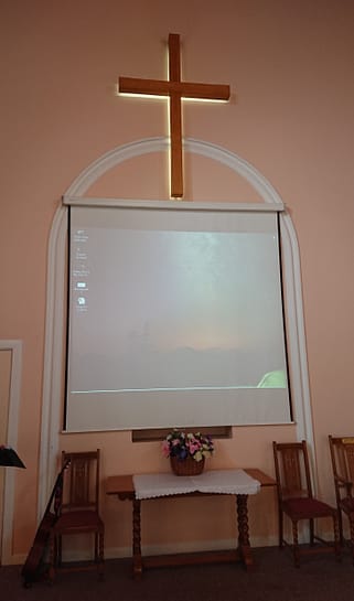
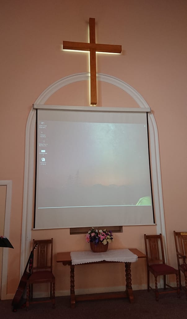
Illuminated cross as it looks today. Photo taken 19th April 2021 for RPBC.
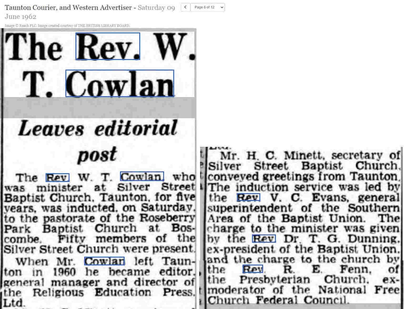
In December 1968 Rev. Cowlan advised the Church Secretary he would be finishing his ministry at RPBC in March 1969 to take up a new job. The Moderator, Rev. John Saunders, wrote that Rev. Cowlan had “been gifted with a warm hearted personality and a strong sense of pastoral care which made him sensitive to our various needs and has led us into fields of Christian fellowship with other Churches in the area and has enriched us more than we know. He has been wonderfully supported by his most gifted wife [Elizabeth], who has so fully identified herself to all aspects of the Church activities as well as using her outstanding dramatic abilities”.92
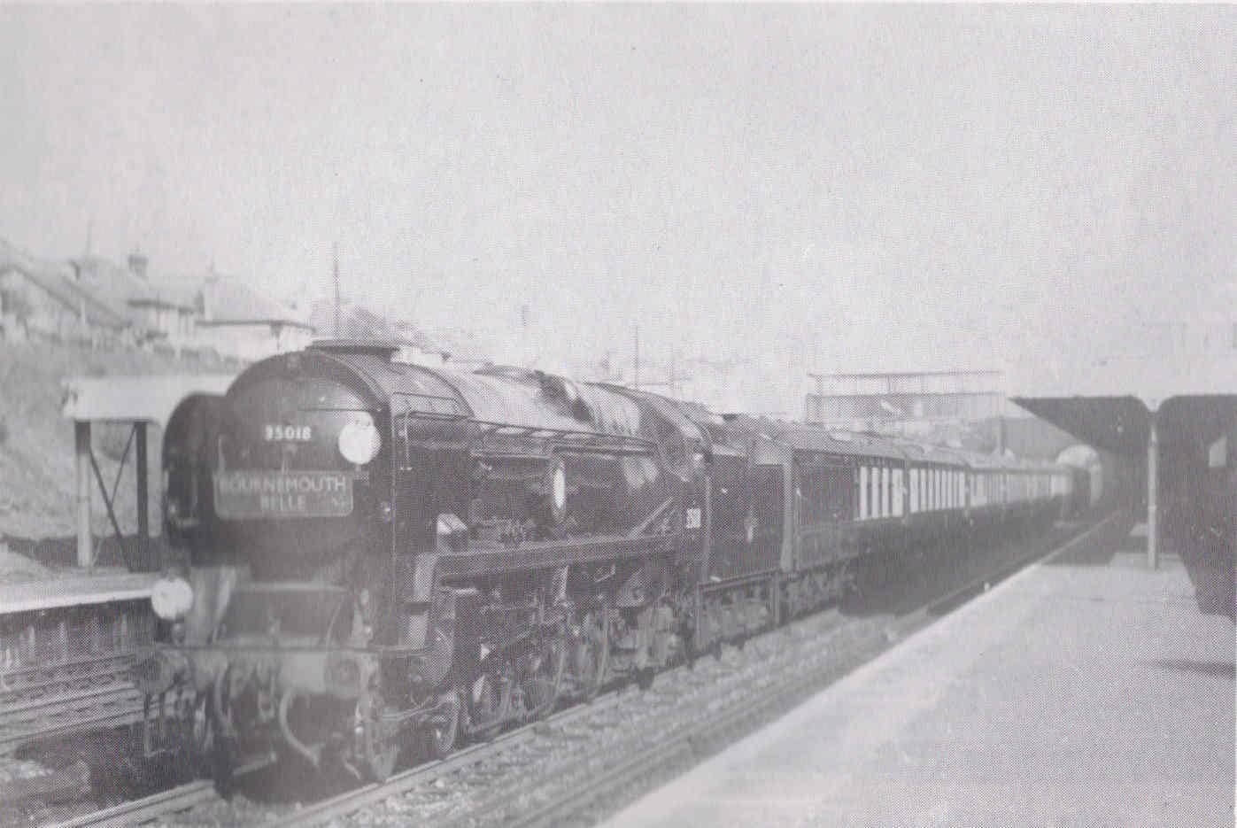
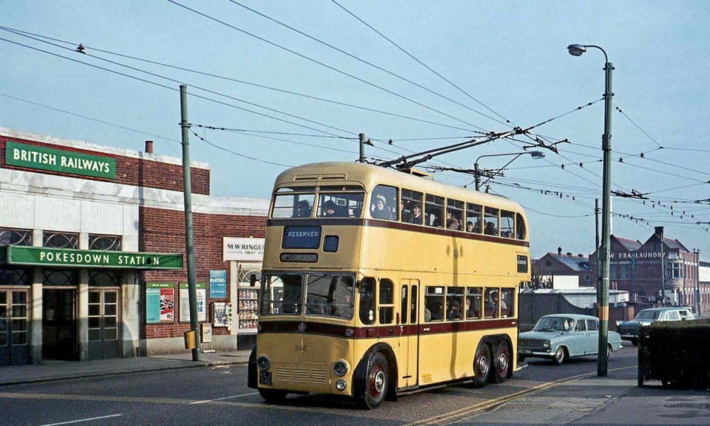
Here’s a nostalgia time-check for you: the end of steam trains! The low price of domestic coal, and an emotional attachment are suggested as two reasons for the procrastination over moving on from using steam engines.93 It took until December 1954 for the British Transport Commission to publish a modernisation plan for the railways, which included replacing steam engines with diesel and electric engines.94 By January 1966 the London Waterloo to Weymouth line was one of the last stretches of railway to still be almost fully steam operated. Its last steam train ran on 8th July 1967.95
The following 1963 publication of ‘The Reshaping of Britain’s Railways’, commonly known as the ‘Beeching Report’96 resulted in Boscombe Station (on Ashley Road) being closed on 4th October 1965.97
I really want to share this photo, but am unable to as there’s been no response to my requests to buy/license it for use here.
Bournemouth Belle passing Pokesdown, April 1959. Source: J.A. Young’s ‘Pokesdown and Iford Yesterday’.
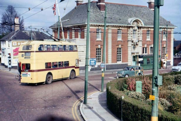
Another major change in transport gave the roads a different look, as the decision was made in 1963 to replace the trolleybuses with diesel buses. No more overhead wires needed! The final trolleybus scheduled service ran on 19th April 1969.98
The copy and paste citation for this page:
The History of Rosebery Park Baptist Church and Pokesdown, Page 14. Author: Michelle Fogg. Date: May 2022. Url: https://roseberypark.org/history/rosebery-park-and-pokesdown-14/
Rosebery Park Baptist Church, 812-814 Christchurch Road, between Boscombe and Pokesdown, Bournemouth, BH7 6DF
The church building before the alterations to the front. Photo from booklet ‘Rosebery Park Baptist Church: The First Hundred Years’ by Robert J. Jeans.
The date of this photo is unknown, but it is after RPBC moved into this building (formerly known as “Keswick Hall”) in 1952, and BEFORE the alterations to the front of the building carried out in 1969/70. (See below for more on this).
“The 15 firemen who are the Pokesdown fire-fleet, work in three separate watches—Red, White and Blue—a nine-hour stint during the day: 15 on the night shift.” They have a button they press to change all the traffic lights at the three-way crossroads to red, allowing the fire engine to “speed on its way”, explains Crawley.84
‘Limelight on Pokesdown’, Christchurch Herald, 1st March 1963, by Tony Crawley:
“Pokesdown today is a big business centre — electrics seeming to be the most popular. Second-hand shops run a close second — they certainly attract the most window-gazers, rummagers and even eventual buyers. The township also houses a Blind Centre in Harrington-road, a Deaf Centre in Morley-road—and the Civil Defence Centre in Seabourne-road. The Astoria Cinema, in Christchurch-road, is owned by Ald. Marry Mears —part of his South Coast chain—and is quick to bring back successful new British and American films for their second local run.”85
“Today’s Pokesdown [Railway Station] -so handy to the main road, buses and taxis on alighting from the trains- has a lift, which is always put at the disposal of the crippled [apologies – not language we would use today] or wheelchair-bound.”86 “Summer time is its busiest time, both for the day excursions snapped up by the local and Southbourne folk—and the incoming holidaymakers.”87
“The New Era laundry works in Scotter-road, Pokesdown is more than 60 years old; this laundry concern was started as a small family business by the father of the present chairman, Mr. S. F. Bell. It is now an immense business—dealing with some 90,000 articles in their summer peak periods. And that includes 20,000 sheets. With its dry-cleaning subsidiary firm, New Era employs a staff of 170, including office personnel—plus a fleet of 15 delivery vans, covering an area from the New Forest to Swanage. Most of the staff have been on the company’s books for all their lives…”88
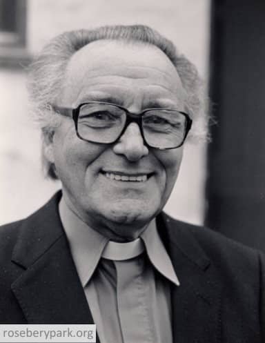
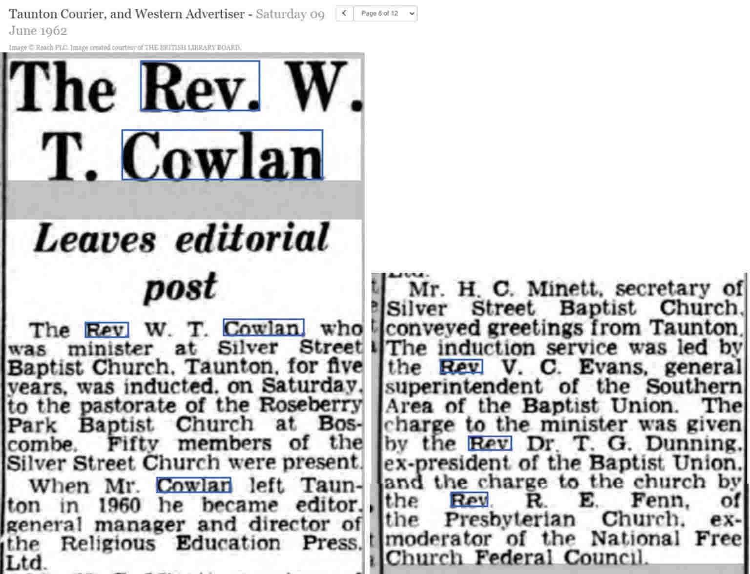
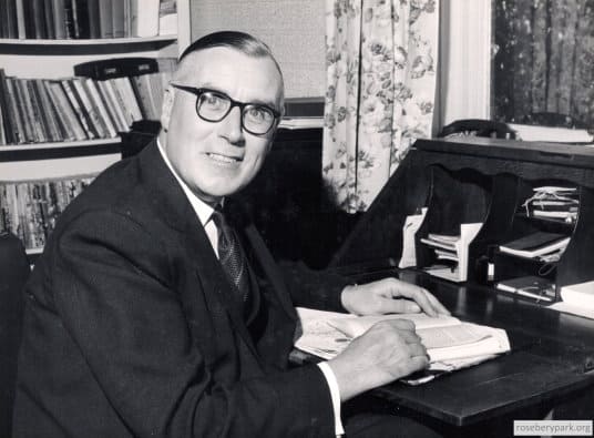
Rev. William Cowlan, Minister 1962 – 1969. Photo property of RPBC.
Rev. William Cowlan, who had been working with the Religious Education Press, became RPBC’s Minister in June 1962. His innovations include a yearly Harvest Sunday bread and cheese lunch to raise funds for Christian Aid, and a charity shop for ‘War On Want’ which raised £87.15s.4d. in donations and over three tons of clothing was sent to Persia and Algeria that year.89
In 1965 everyone who had connections with the church was invited to complete pro formas indicating what service they could offer and what need they had which they felt the Church could offer them, in the “Time, Talent & Treasure” stewardship programme. Some of the young people formed a guitar group, in 1964, called The Saints! Also on the theme of music, a new organ, a Hammond TR3, was purchased and dedicated in June 1966.90
The copy and paste citation for this page:
The History of Rosebery Park Baptist Church and Pokesdown, Page 13. Author: Michelle Fogg. Date: May 2022. Url: https://roseberypark.org/history/rosebery-park-and-pokesdown-13/